Built for the Water
Lighting the Way Below – Enhancing Every Dive
Underwater Glow, Unmatched Visibility
Tags: 1st Class Eligible, Brand_C-MAP, Cartography, Cartography | C-Map 4D, MRP, Restricted From 3rd Party Platforms
SKU: BPD-80867
Category: C map
Vendor:C-MAP
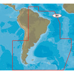
4D SA-D501 Gulf of Paria to Cape Horn
With C-MAP’s detailed cartography and extensive database of local information at your fingertips you’ll never be lost, even in unfamiliar waters.
Dominate the water with C-MAP’s full vector charts, harbor and approach details, tide and current tools, and more.
Full-Feature Vector Charts give you tools like tidal streams, detailed roads, and accurate marina plans, giving you the utmost situational awareness in your covered area.
High-Definition Aerial Photography will ensure you get the best view of where you are and where you’re going even in sub-optimal conditions.
Expandability is built-in to these cards via Value Added Data Segments (sold separately) so that when you need that extra local detail, adding it to the charts you already use is hassle-free.
One Free Year of daily updates means you will have the most accurate, up-to-date information available, keeping you and your crew safe out on the water.
Coverage:
Features:

RECENTLY VIEWED PRODUCTS
Built for the Water
Lighting the Way Below – Enhancing Every Dive
Underwater Glow, Unmatched Visibility
![C-MAP 4D SA-D501 Gulf of Paria to Cape Horn [M-SA-D501-MS]](http://boatpartsdepot.com/cdn/shop/files/Untitled_design_-_2024-08-28T110403.265.png?v=1724825283&width=3840)



![C-MAP 4D SA-D501 Gulf of Paria to Cape Horn [M-SA-D501-MS]](http://boatpartsdepot.com/cdn/shop/files/80867XL_180x.jpg?v=1723513261)
